Government
Marengo Votes to Sell 89 Acres of Kishwaukee River Floodplain to the Conservation District
The short version: The Marengo City Council voted 8-0 on Nov. 9 to sell about 89 acres of city-owned land along the Kishwaukee River, west of Deerpass Road, to the McHenry County Conservation District for $256,300.50. The city bought the land in 2014, and staff told the council the proceeds are budgeted for the police pension fund and IT upgrades.
Thursday, November 12, 2026
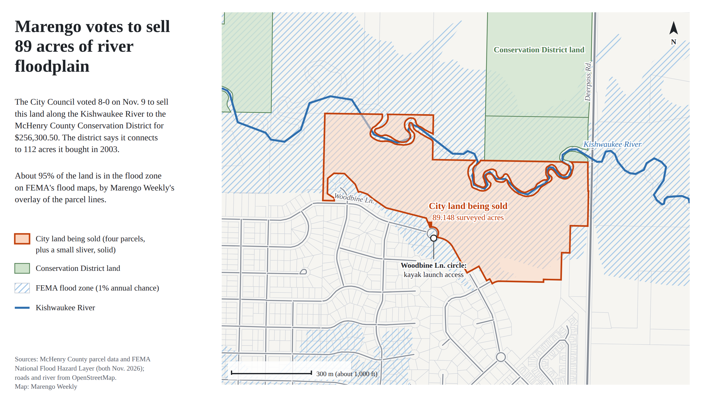
The Marengo City Council voted 8-0 on Monday, Nov. 9 to sell about 89 acres of city-owned land along the Kishwaukee River, west of Deerpass Road, to the McHenry County Conservation District for $256,300.50.
The sale ordinance describes the land as vacant floodplain that the city no longer needs for its operations. About 95% of it sits in the river's flood zone on FEMA's flood maps, by Marengo Weekly's overlay of the parcel lines, and on aerial photos the Kishwaukee winds along and through the north end of the property.
The Price
The price traces back to March. On March 9, coming out of a closed session, the council voted 8-0 to approve a sale contract with the district at 80% of the city's appraised value, priced by the acre. The final figure waited on a survey, which came back at 89.148 acres. At $2,875 an acre, that is $256,300.50.
Asked about the land on Monday, city staff said the deal had been in the works for about eight months, priced off the appraisal and finished by the survey.
How the City Came to Own It
The land belonged to the estate of Leonard Besinger, held in a land trust. In July 2012 the council approved buying 76.3 acres of it for $152,600. A month later, the city administrator reported a conflict over the acreage: about 67 acres available, against the 76.3 on the tax records.
On Sept. 23, 2013, the council approved a new deal: 91 acres for $225,000, most of it covered by a $200,000 loan from Castle Bank. The purchase passed 6-2, with the mayor voting yes, and the loan passed 5-2. The city closed on the purchase in late 2014; the deed was recorded on Nov. 24, 2014.
Where the Money Goes
Asked where the proceeds would go, city staff told the council, "$150,000, I believe, will go towards the police pension fund," and that about $100,000 more was penciled in for IT upgrades, both already built into the city's budget. A city IT security assessment is nearly finished, and the council expects to discuss what it finds once the report is in. One alderperson said they would rather see the money go to streets.
The sale ordinance itself does not say where the money goes. The police pension fund was 55% funded at the end of the fiscal year that closed April 30, up from 45% a year earlier, according to the audit presented to the council on Oct. 26. The auditor credited the city's pension levy, an added city contribution and investment returns for the gain.
What the District Gets
The Conservation District's board approved its side of the deal on March 19, 5-0. In June its board approved a grant agreement with the Prairie State Conservation Coalition for up to $100,000 or 39% of the purchase price, whichever is less, toward what the district calls the "Kishwaukee Corridor Addition." The district says the new land connects to 112 acres it bought in 2003 at the southwest corner of River and Deerpass roads, and that those connections make important wildlife corridors.
In June the district's board also ratified a letter agreement adding a fifth city parcel to the sale, a sliver of less than a tenth of an acre near the circle at the east end of Woodbine Lane. The four larger parcels are the ones the council listed in March.
What the district will do with the land is mostly still open. A district spokesperson said the main goal is protecting the habitat: 66 acres of floodplain forest, including areas the Illinois Natural Area Inventory identifies as high quality, 23 acres of woodland and nearly 4,000 feet of the Kishwaukee River. Public access, including hiking and paddling, will be shaped by a long-range conservation plan the district expects to finish in the next few months, once its board accepts it.
That includes the Woodbine kayak launch at the east end of Woodbine Lane, which the district understands is on or passes through the land. The spokesperson said the plan will help guide access and use once the district owns the property. The district is aiming to close the sale on or before Nov. 30.
The land is tax-exempt as city property, and state law exempts land owned by conservation districts, so it stays off the tax rolls.
The council's approval is subject to the city attorney signing off on the final agreement.
Marengo Weekly reviewed the Nov. 9, 2026 council packet; city council minutes from July 2012 through November 2014 and March 9, 2026; McHenry County Conservation District board minutes from January through September 2026; McHenry County recorder and assessor records; FEMA flood maps; county aerial photos from April 2026; its own recording of the Nov. 9 meeting; and written answers from the Conservation District.